Thursday, February 28, 2013

Not Much is New

Today was cloudy and overall dreary and in the lower 30's.  Tomorrow will most likely be similar but slightly cooler.  Nothing looks overly interesting.  Maybe the jet stream is still a bit odd,  there continues to be a sort of swirling movement above us and also in the east.


It's currently cloudy at 23°F with a northeast wind going 10 mph and a dew point of 13°F.

Tuesday, February 26, 2013

Walking Into the Wind

Today was pretty much the same as yesterday, mostly cloudy and in the mid 30's.  I expect tomorrow will be similar as well.  I did however notice something odd today, as I was walking home I realized that instead of walking in a similar direction of the wind as I usually do, I was walking into the wind.  This means the wind was coming from a more easterly direction.  As we can see from from this map the jet stream is coming from the east then curling back around toward the east again which is pretty unusual.

It is currently mostly cloudy at 32°F with northeast wind going 9 mph with a dew point of 24°F.

Monday, February 25, 2013

A Bit of Sun

It's been quite the week in weather.  Winter storm Q blew in early friday dumping about 8 inches of snow on us.  It has also warmed up quite a bit in the last few days.  Yesterday was a beautiful day with some sun and pretty sweet clouds.
Proof:

The next few days will continue to be in the upper 30's and will most likely be sunny tomorrow.   There's a high pressure area making its way over creating the warmer temperatures and should be keeping the skies relatively clear.

It is currently cloudy at 28°F with a dew point of 24°F and NE winds at 5 mph.

Saturday, February 16, 2013

This week began unusually warm for this time of year, and it has been ridiculously slippery trying to walk to classes.  Yesterday was mostly sunny in the mid teens and has cooled down a bit compared to earlier in the week.  A high pressure area from the west moved in creating sunny conditions for today and most likely continue through tomorrow as well.  By looking at the map, it seems that a warm front is on its way which should bring the temperatures back up again.


Current conditions this evening are clear at 5°F with southeast winds at 1 mph and a dew point of -2°F.

Sunday, February 10, 2013

This Is Icky

It's been a while since my last post, but last week was pretty much the same thing repeating over and over due to the aforementioned Alberta Clippers.  However things started picking up today and became quite interesting -a bit too interesting if you're the lucky one that gets to drive halfway across the state traveling at 30mph on the freeway passing a dozen cars in the ditch...  


Anyways, as you can see here there's a pretty intense low pressure area moving its way through Wisconsin creating some pretty unfortunately timed rain/snow/sleet that makes driving through it for 5 hours a ton of fun.  

Check it.  Bleak.


But the party's not over because the system is still getting shoved around and we're about to get a "wintery mix" moving into snow to go on top of all the rain we've gotten.  So if you're going to be out and about anytime soon, be careful kids because I imagine it's going to get a bit (more) slippery out there.

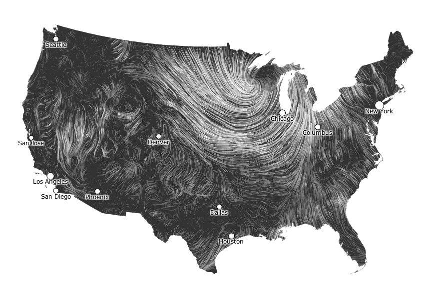
Here's a screenshot of the direction and intensity of the wind so we can see how the wintery mix system from the west will swing down and back up and get us from the south.  At the moment it is 35°F with a south/southwest wind at 8mph with a dew point at 33°F.  

Tuesday, February 5, 2013

Boring Februaries

In class this morning we were told about something called Alberta Clippers.  This is when an area of low pressure that forms in Canada rushes southeast into the great lakes area creating a pattern including strong wind, cold temperature, and a light dusting of snow.  This is very common for around the month of February and we can see that over the past few days, it has been precisely the pattern.  It would seem that the pattern will continue tomorrow as well, as we can see, there is some precipitation toward the west coast that will likely make its way over here to create another light dusting of snow for tomorrow sometime.


Today's high was 26°F with north, northwest wind at around 15 mph.  It was 78% humidity and mainly overcast for most of the day, then seemed to clear up in the afternoon.  

Monday, February 4, 2013

Weekend Redundancy

This weekend was very similar to Friday as it was beautifully sunny for most of the day then became overcast later into the afternoon then proceeded to lightly snow during the night.  Here's a picture of some sweet light wispy clouds I took yesterday whilst trapped in Haas working on a project.  


Today was more of the same.  Thankfully it has warmed up a bit in comparison to last week.  Right now it is partly cloudy, with south wind at 4 mph and a relatively decent 26°F.  By the looks of the radar, it's probably going to snow a bit tonight too.  


Friday, February 1, 2013

Frozen Eyelashes

As expected, it was even colder outside today.  With a high of 2° and still pretty windy, my eyelashes froze shut on my way to class this morning even though it was sunny.  Later on it started snowing.  I assume the weather will be similar tomorrow, though hopefully a bit warmer.